
• All things technology
  • Delivery within Europe
  • Right to Cancel applies
  • Specialist retailer since 1923

Garmin eTrex Touch Outdoor GPS Hiking, Cycling, Skiing, Geocaching, Sailing GPS, GLONASS

EAN:
Part number:
Item no:
1/10
Datasheet (PDF)
Fast track dispatch on Tue 27 Oct

26 Piece(s)
Sales and shipping:
Conrad ElectronicTerms & Conditions

Number
Total (€ 479.00 / piece)
€ 479.00
prav.tax.untaxed incl. VAT 
plus € 19.99 
prav.priceAvailability.ecoparticipation.cost ...
prav.priceAvailability.privatecopyingfee.cost ...
without further shipping costs 
14-day return policy included

Highlights & Details

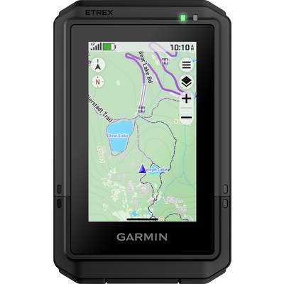
Garmin eTrex Touch Outdoor GPS

  • Outdoor handheld device with 3" (7.6 cm) color touch display
  • New and robust design in pocket size
  • Handheld device for outdoor activities like hiking, biking, skiing, kayaking, geocaching and more
  • Pre-installed TopoActive maps
  • Compatibility with outdoor maps+
  • Round-trip routing
  • Precise position determination thanks to multi-frequency reception
  • Battery runtime of up to 130 hours with SatIQ technology
  • USB-C interface
  • New brackets for more attachment options, e.g. for your bicycle

Technical specifications

  • Battery life: All satellite systems + multiband: Up to 130 hours, expedition mode: Up to 650 hours
  • Interface USB-C
  • Memory/log: 32 GB (the available space for users depends on the built-in cards)
  • Dimensions: 66 mm x 105.4 mm x 24.6 mm (2.6-inch x 4.15-inch x 0.97-inch)
  • Water-tightness IP67
  • Display type: 3 inch transflective TFT color display
  • Display size: 3.88 cm x 6.48 cm (1.53-inch x 2.55-inch); 7.62 cm (3-inch) diagonal
  • Display glass: Chemically reinforced glass
Use

Hiking

Cycling

Skiing

Geocaching

Sailing

Product type

Geocaching

Features

GPS

GLONASS

Screen size diagonal (inches)

3 inch

Display (cm)

7.6 cm

Max. battery life

650 h

Width

66 mm

Height

105.4 mm

Depth

24.6 mm

Weight

150 g

Dim

(W x H x D) 66 x 105.4 x 24.6 mm

UKCA

not relevant

Documents & Downloads

Datasheet

Datasheet 3521416 Garmin eTrex Touch Outdoor GPS Hiking, Cycling, Skiing, Geocaching, Sailing GPS, GLONASS

User & Safety Instructions

User & Safety Instructions 3521416 Garmin eTrex Touch Outdoor GPS Hiking, Cycling, Skiing, Geocaching, Sailing GPS, GLONASS

Description

Get on the adventure with the eTrex® Touch. The robust handheld GPS was specially developed for outdoor experiences and extreme weather conditions (waterproof according to IP67). On the high-resolution and colored 3-inch (7.6 cm) touch-display all the data can be read very well even when the sun shines. It includes maps for trails and roads so that you can easily swipe and zoom over the display to follow your route. In addition, you can also access the mobile Garmin Explore APP for route planning. Receive with Outdoor Maps+ access to premium map contents (subscription necessary). Multi-frequency reception keeps track of your position so you know exactly where you are. The built-in battery lasts for up to 130 hours with SatIQ technology – so you can enjoy your favorite activities for even longer.

This text is machine translated.

Scope of delivery

  • ETrex Touch, charging/data cable and documentation

What kind of Outdoor Navigation are you looking for?

Accessories

(*All information is plus legal VAT)

The necessary accessories are required to use the article as described.